
Caliche - Designing with Curiosity
Landscape architecture is built from basic materials: stone, cement, wood, metal, soil, plants. At the same time, the medium impacts matters of public space that require extraordinary nuance. The composition of slope and elevation, texture, porosity, hardness and softness, compression and release, all culminate in a variety of emotive experiences for humans and consequences for environmental and ecological performance. Handling material things with curiosity—in this case caliche—can enable important work across complex stakeholder groups, jurisdictions, and communities to rethink urban spaces together.
Creating public landscapes for the health of humans and non-humans alike is also a growing cultural priority across the planet. Landscape architects have emerged as necessary actors in optimizing limited space for public benefit and repairing the legacy of harmful land uses with new connections to natural environments. This task requires constant research.
Caliche is the sedimentary mineral layer that forms just above limestone when thin soils dry out in extreme heat and draw moisture and calcareous particles up from the bedrock below. In geologic terms, caliche is extraordinarily young, forming a few thousand to roughly 5 million years ago. It’s also a waste product—pried from the earth to gain access to limestone before it is hauled to line quarry fields or be crushed for base material. While too weak for architectural uses, it has become a key material component of MVVA’s work to renaturalize Austin’s Waller Creek as the core of Waterloo Greenway.

Waller Creek
In 2013, MVVA was awarded the Waterloo Greenway project after several rounds of qualifications, reviews with technical committees, booklet submissions, and interviews. The competition was framed around the “wicked” problem of the blighted, intensely urban Waller Creek—a site webbed with interconnected technical, cultural, social, and administrative challenges. Running through the heart of Austin, Waller Creek is constrained within a corridor crowded with infrastructure. There was no silver bullet, no singular design gesture that would solve all of this. Instead, a dense collection of working concepts went into our submission, fabricated out of the highly varied conditions found along the creek—a bricolage approach to shaping the character of this new public space. This book follows one of these working concepts and explores how it has played out over a decade of iteration, material exploration, and applied research amid a legion of other efforts to design and implement the project.
The workflow for Waterloo Greenway is inherently messy because we have embraced the idiosyncrasies of the existing creek channel—its geological instability, its hydrological burdens, its ‘grey area’ status amid various regulatory bodies, and so on. The creek’s once-gradual slopes long ago gave way to an inchoate mix of near vertical stability measures desperately designed to protect adjacent real estate interests. This was a collection of architectural site walls, concrete revetments, shotcrete slopes, gabions, stone walls, bare eroded slopes, and invasive-filled patches. Battered by the unrelenting stormwater flow conveyed by pipes and overland runoff, the creek landscape had fallen into a pattern of slow decline recorded in the assortment of green patches amid these armored scales of human invention. As a patchwork of physical artifacts, ephemeral habitats, and jurisdictions, this project compels us to begin every design conversation by asking ourselves what should be removed and what should remain?

MVVA and Thomas Phifer & Partners’ winning competition presentation for Design Waller Greek: A Compeition organized by the Austin-based Waller Creek Conservancy, 2012.
It was neither affordable nor productive to attempt a restoration of the entire creek system. Restoration is a problematic concept in these contexts. We would restore the creek to what? To when? Instead, we looked at how to honor this oddball, 150-year-old dialogue between Austin’s efforts to armor against storms and nature’s haphazard battle to reclaim the disturbed landscape. Our first on-the-ground look at the creek prompted us to envision a Greenway that would present an “uncanny experience of regional ecologies,” neither wholly natural nor constructed.
The haggard condition of the banks demanded a form of stability that could better integrate the creek into its rapidly urbanizing circumstances but also leave room for riparian landscape—plant communities that thrive by their adjacency to a dynamic water body. However, every turn of this watercourse showed us how conventional solutions would ultimately fail. It was a catalogue of how engineered bank stabilization breaks down: concrete revetments fragmented like broken crackers, gabions slumped into slipshod piles, shotcrete pulled apart by invasive cane and water scour. Explorations of the existing corridor revealed that stacked limestone walls fared best in staving off the creek’s assault, but they were ecologically inert.
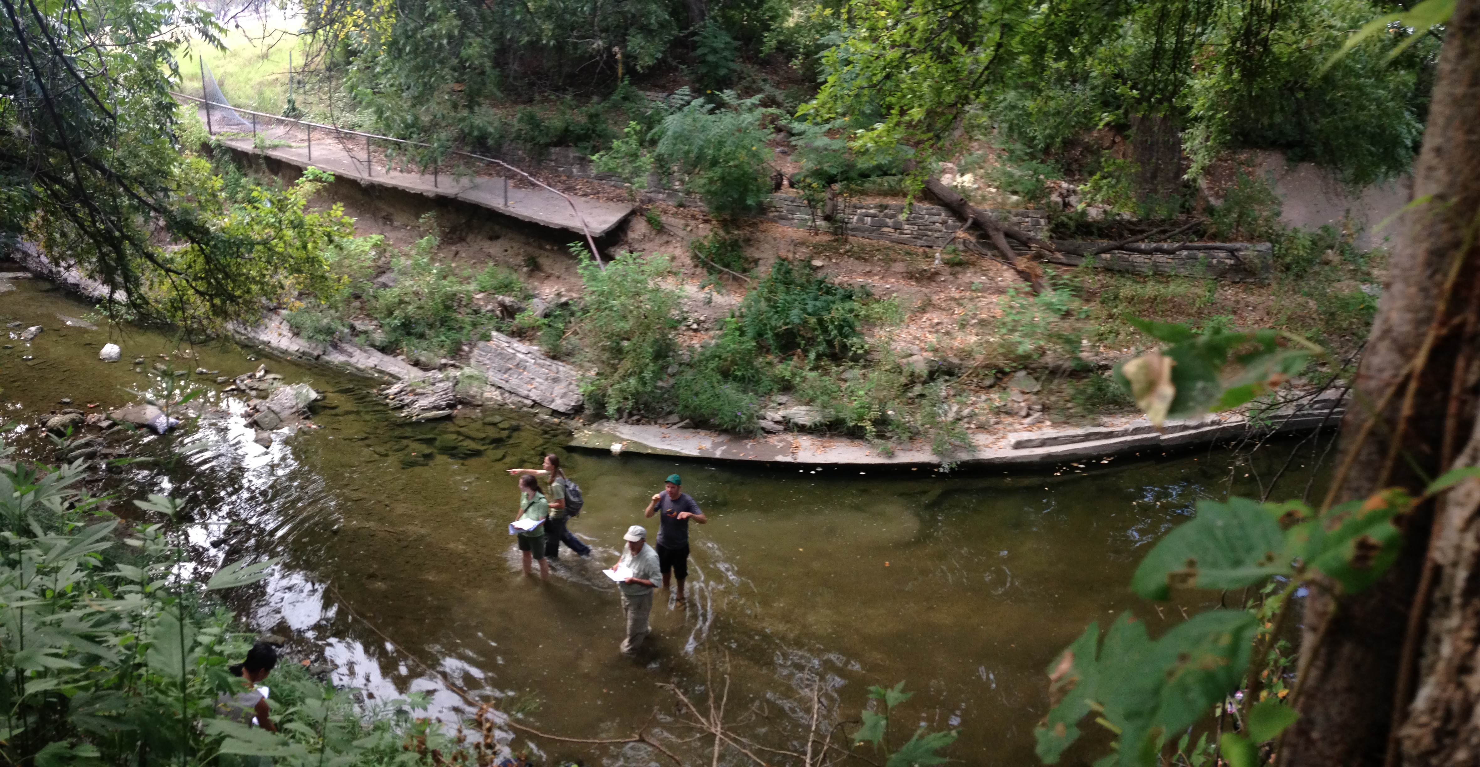
MVVA site visit at Waller Creek, 2013.

The Grotto at San Pedro Springs Park was originally built as a "summer house" for parkgoers to keep food cool.
Our competition entry expressed numerous ways to wrestle with stability. A series of process sketches, which I called “mud pie architecture” at the time, were doodled in the margins of our submission book. These drawings explore the idea of structures that simultaneously retain slopes and create footholds for native vegetation through crude compositions of Texas quarried stone, boulders, gravels, mud, cement, mortars, plants, and water. The Grotto, an utterly unusual structure that we happened upon in San Pedro Springs Park on our way to Austin, was an iconic reference for us in our search—so much so that we even explored how we might reconstruct a facsimile of this living-nature-structure-thing on Waller Creek. We hadn’t realized it yet, but we had begun to wade into a decade-long cycle of applied research in inviting nature back into this setting.
Waterloo Greenway only became possible with a massive engineering project—designed prior to the competition—for a flood bypass tunnel that diverts the creek’s flow into the bedrock beneath downtown and into Lady Bird Lake, one of a chain of reservoirs on the Colorado River. Crucially, the tunnel also draws water back up from the river to reintroduce flows in the creek channel as it passes through downtown. This project created an engineered headwaters at the top of a 1.5-mile stretch of Waller Creek, which coincides with the tunnel inlet at Waterloo Park. One of our first challenges was to rethink how this moment would engage the public and the creek’s ecology. The tunnel engineers’ drawings originally featured a pipe that belched water into a concrete-lined creek channel, but we knew the headwaters could do more. We were enticed by opportunities to reveal the water in a manner that connects Waller Creek to the region’s geomorphology. While it will always come from a pipe, should it express itself as a spring, a pool, a seep?

The Waller Creek flood bypass tunnel, completed in 2016, would liberate 28-acres of downtown property from flood impacts but utterly change the flow regime of Waller Creek.
The Nature of Texas Limestone
Quarrying in Texas is largely a makeshift industry. Sawing, prying, and pulling stone out of the earth is often born out of a subsistence strategy for privately-owned range lands. The limestone quarries that ring Austin are fabricating architectural cladding and landscaping materials to serve the city’s explosive growth over the last twenty years. This boom economy has been reflected in an aesthetic proclivity for “natural-faced” limestone, the surface created not by a saw but by eons of organic matter compressed between further eons of mineral material called bedding planes, reflecting a cycle of ancient lake bed landscapes flourishing and collapsing. This preference for a surface shaped by geologic forces reflects a particular quirk in our aesthetics—to covet something older and deeper than our own lifetimes, our history as a species.
But presenting this primordial, organic surface perpendicular to the orientation in which the stone formed is wholly unnatural. The region’s creeks and rivers that cut through bedrock reveal strata that speak to the lake bed’s history, and these organic seams serve an important function in conveying groundwaters laterally. Water roughly follows the subsurface topography and expresses itself on the sides of springs, caves, creeks, and rivers, creating seasonal seeping flows. Visiting locations like Bear Creek or Dripping Springs, one can find incredible beauty in the delicate landscapes that emerge from these walls.


Krause Springs (top) and Bear Creek (bottom)
Bedrock is always relatively close to the surface in Texas. The state’s shallow soil layers famously contribute to flash flooding in the region as the volume of soil cannot absorb the moisture from the vast area of surface runoff. This creates a fractal geography across the eastern half of the state, where nine rivers, thousands of creeks, and innumerable headwater springs are formed by the runoff of central Texas and convey water to the Gulf of Mexico. These waterways create a constellation of beautiful water-limestone expressions that punctuate the vast and often brutally dry Texas landscape. Hamilton Pool, Barton Springs, Blue Hole, Perdernales Falls, San Marcos River, and Krause Springs are considered essential cultural touchpoints and sacred resources by many.
The juxtaposition of stone forms shaped by humans and stone forms shaped by nature highlights a tension in the work on Waller Creek. Because of the urban density along the creek, reimagining it as a natural system could not be achieved through traditional restoration methods, which often entail laying back slopes. Instead, we needed to invent methods of re-naturalization on nearly vertical surfaces, inviting nature to animate an unnatural slope. We then started our search for some way the variety in limestone expressions might help us accomplish this goal—for a material that could straddle humans’ hurried desire for engineered stability and nature’s slow and grinding appetite for change.


Finding Strength in Weakness
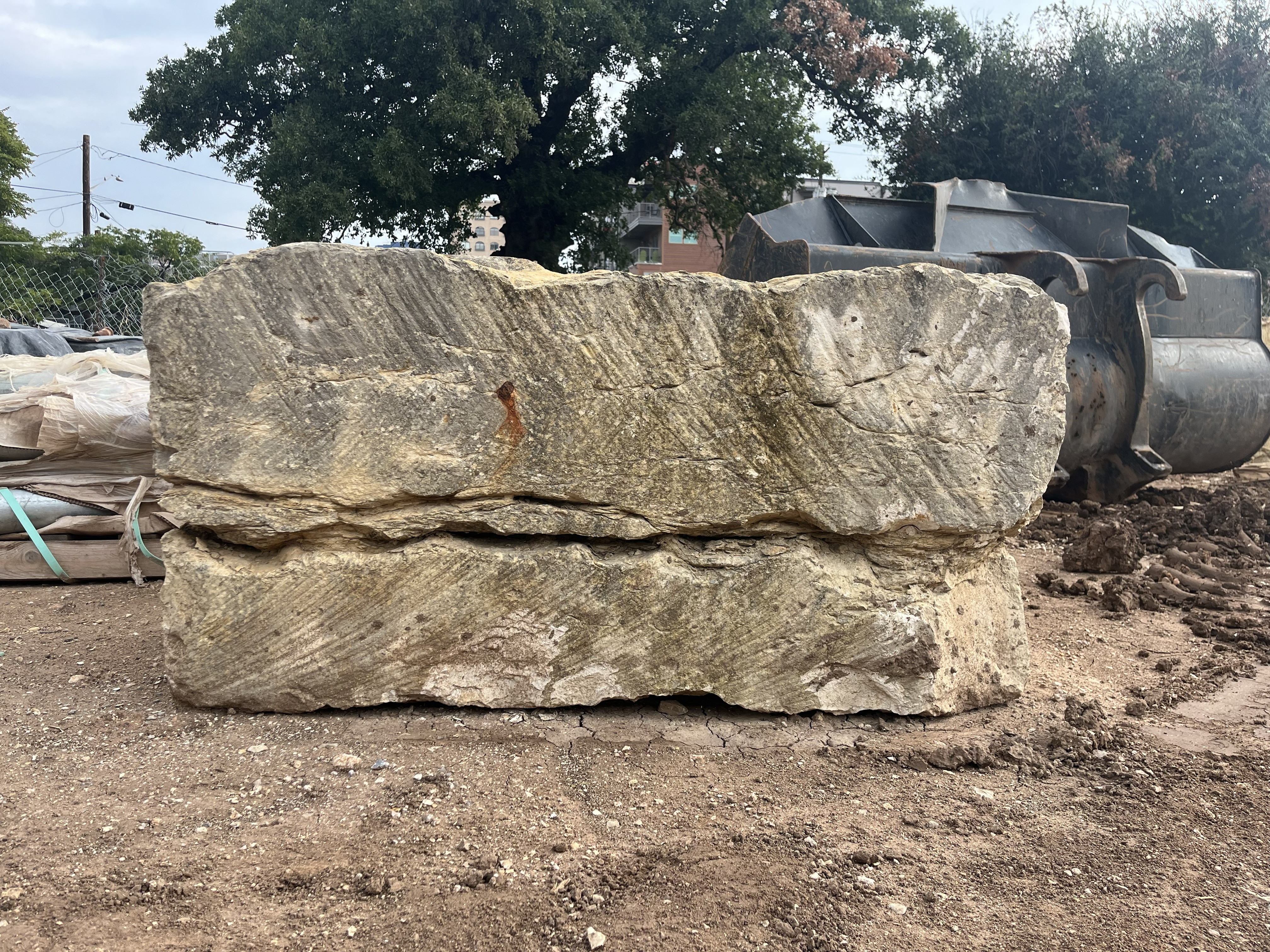
The methodology for extracting limestone involves peeling away the stratigraphy below, layer by layer. To gain access to the denser layers of bedrock, the topsoil must be stripped and the uppermost layer, called caliche, must be cleared. For efficient removal, it is sawn into a grid of large blocks (roughly 36” long by 48” wide, 36”-42” deep, and weighing over 3 tons each), lifted by front end loaders, and then tossed into nearby fields. Each quarry has its own sectional catalogue of the strata below, and a quarry-specific nomenclature captures the layer depths, color, and texture—“rattlesnake,” “glassy cream,” “nicotine,” “shitblock,” etc. But at all these quarries, the caliche layer is just called “caliche.”
Quarries receive visitors and clients by quickly orienting people to their facilities and standard products. In May of 2015, no more than 10 minutes into our tour at Superior Stone located an hour north of Austin, amid the organized piles of stone being shipped out of the quarry, I spot an overgrown field full of large blocks of castaway rock. Already a bit bored with the quarry products spiel, I wander over to this field and explore. The larger group eventually notices that I am no longer with them, and they try to collect me to continue the quarry tour. But I draw our client’s attention to the beauty of the stone blocks in front of us. I ask the quarry manager what material that is. “Oh, that is caliche…it’s really not useful for building.” He explains that when rotated and stacked like limestone, the veining of caliche’s horizontal strata splits easily, and the blocks delaminate.

The top surface that interfaces with topsoil is especially friable and can be picked apart by hand. This is the front line where the material forms. Moisture drawn from karst layers below pulls microscopic limestone dust that bonds with the clay particles in the soil.


Caliche forms when calcium particles mixes with the clay of the soil, accumulating into aggregates that are compressed into solid beds over time. This is why the horizontal natural face of caliche is particularly friable, as this surface is a physio-chemical interface with the soil at the front line of the rock’s formation. It is a hybrid substance drawing upon both the bedrock below and the soils above. As such, caliche’s cut faces reveal robust amounts of organic and clay-filled seams. This softer stone has a tremendous amount of character on its edges, reminiscent of the surface of Jupiter—a planet made of swirling liquids and gases.
The instability of this material as a facing or architectural wall gives caliche little immediate value in most construction contexts, but that day seeded the idea of how this stone could hold unexpected landscape potential. Drawn in by its appearance and material properties, the Waller Creek project team explored using caliche in a novel gravity wall system with a friable surface that might become an asset for re-naturalization. The caliche blocks could well be used for slope stability as a gravity wall, but the material’s weakness could also catalyze, bridge, or hold potential for ecological succession.
Chia Pet
There was no testing for the density or compressive strength of caliche because it would certainly fail with its natural face positioned vertically. But why not orient these giant blocks horizontally, the way they sat for millions of years? This way, the caliche faces could invite both the physiochemical dynamic that led to the material’s formation and the plant species that opportunistically seek out low soil, high pH environments. Under the right circumstances, these blocks could become “chia pets” on Waller Creek where vegetation might spring out of gaps, pockets, valleys, seams.
Apparently the first gravity wall of its kind, the caliche block slopes have evolved into an expanding lexicon for a constructed geology along Waterloo Greenway. This has become a playbook for how to replace normative riparian features with novel niches for habitat through a system better suited to the urban circumstances of Waller Creek. So far, we have developed and begun implementing headwater springs, sediment ramps, flood benches and settling basins, and the bedrock floor. All these elements restore natural function through the physical and chemical characteristics of caliche—a microcosm of the larger work to regraft the once-natural creek to the city evolving around it.
